Directions
We will leave the centre at 9:15 and will arrive at Avery Court at around 9:30. We will use the connector trail to get to the Thetis Lake car park (1.3 k each way) to complete the feature hike (short version - about 1 hour) and return via the connector trail.
Track
View Thetis Lake From Phelps Avenue - October 22, 2013 in a larger map
Viewranger map
Slideshow
Photos
Details
| Name: | Thetis lake connector | |
| Date: | Aug 21, 2012 9:28 am | |
| Map: (valid until Feb 17, 2013) | View on Map | |
| Distance: | 7.15 kilometers | |
| Elapsed Time: | 1:39:29 | |
| Avg Speed: | 4.3 km/h | |
| Max Speed: | 12.0 km/h | |
| Avg Pace: | 13' 55" per km | |
| Min Altitude: | 43 m | |
| Max Altitude: | 133 m | |
| Start Time: | 2012-08-21T16:28:22Z | |
| Start Location: | ||
| Latitude: | 48º 27' 49" N | |
| Longitude: | 123º 29' 08" W | |
| End Location: | ||
| Latitude: | 48º 27' 49" N | |
| Longitude: | 123º 29' 08" W | |
Feature Hike
Feature Hike
Thetis Lake Regional Park
Lewis Clark Trail to Seymour Hill
Trail Rating: Moderate
Approximate Hiking Time: 1 to 1.5 hours
Approximate Hiking Time: 1 to 1.5 hours
Highlights
This hike gives you a nice taste of the variety this park has to offer. You'll get some good exercise, fabulous views at the top and a sampling of the lakeshore trail on the way back.
The Hike
Begin your hike at the map kiosk at the end of the parking lot. From here, take the right hand trail. It's a gradual climb through Douglas-fir forest into Garry oak/arbutus/Douglas-fir woodland. Once up there, the trail winds up and down, with great hilltop views and dappled woodland trails.
Where the trail meets up with the Seymour Hill Trail, take a right up the hill. A directional cairn near the 131-metre summit, built in 1968 by the Thetis Lake Nature Sanctuary Association, provides sight lines of local mountains, including Mount Finlayson and Mount Work. The nearby view looking down on the lakes is magnificent, making this a "lunch-worthy" spot.
To find the trail down the other side, make a left from the cairn (when your back is to the lakes). The first portion of this trail is steep, so tread with care. Keep to your left along this trail and it will take you back to the trail that skirts Lower Thetis Lake. A left turn along this trail will take you along the lake back to the parking lot.
Option
If you want to extend your hike, turn to the right and you have the option of taking the trail around one or both lakes. Total hiking time including an extended trek around both lakes is 2.5 to 3 hours.
Google Map
View Larger Map
Trail map
Connector Trail Map
Description of Tuesday, October 18, 2011 hike
Welcome to Carol who joined the group this morning. We had an excellent hike thanks partly to Dwayne for having checked out the trail yesterday, and partly to the weather for being so pleasant. The connector trail is an excellent way to get to Thetis Lake Park from Langford on foot. From the main car park at Thetis, the Seymour Hill Trail was excellent and as described in the feature hike below. The water was like a sheet of glass this morning.

We did stop a couple of times to admire the view, and we deviated from the feature hike by turning right to complete a loop of Lower Thetis Lake on the way back to the connector trail. Overall it was about 8K and an excellent hike to add to our growing collection.

This plaque is dedicated to Dr. Lewis J Clark the conservationist. Not to be confused with Lewis and Clark, who were in fact two different people completely. Notice the stone crop!
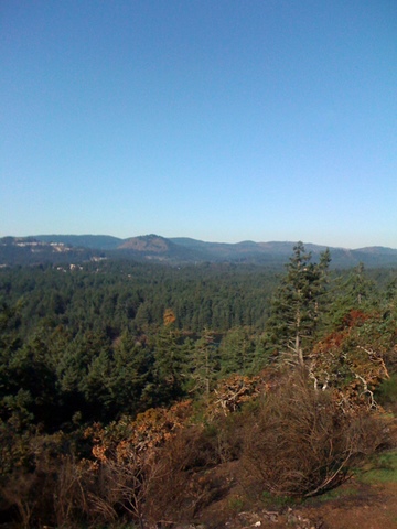
As I said, the views were extra especially spectacular and were particularly good this morning.

This hike is a keeper - the connector trail followed by a loop of Lower Thetis with an associated loop of Seymour Hill Trail. As Kathy said - a loop de loop!
Thanks to Dwayne for these pics from his recon yesterday!


Great pics.
No comments:
Post a Comment