Wednesday, January 30, 2013
GG5 5521 Sooke Road to Kilometer 49 - Sooke Potholes Feb 4, 2013
Track
View Galloping Goose 5 Feb. 5, 2013 in a larger map
Thanks, Dwayne, for the track and slideshow
Directions
We'll meet at last week's stop - the parking lot at 5512 Sooke Road. It's about 10 K to the next stop - the top parking lot at Sooke Potholes. We will board the vehicle left there for the return trip to the Sooke Road lot.
Parking Lot
View Larger Map
Check out the park brochure showing the parking next to the 49K marker
Description from official guide
Near Coopers Cove (3 km west of Roche Cove) the Goose heads north
across Sooke Road (use extreme caution on this busy highway!) and
visits the neighbourhood of Ayum Creek before heading north into the
Sooke River Valley.
Here the Goose climbs out of the coastal plain and up the canyon. Far
below, the Sooke River plunges and swirls past potholes, and hustles out
to sea. The original railway once spanned Charters and Todd creeks.
Today only tall iron and wooden trestles remain, upgraded in 1995 to
safely handle foot and bicycle use.
The view from the trail perched on the side of the canyon is breathtaking. If you’re on horseback, watch for signs indicating a bypass trail with stream crossing for horses.
There is no direct access to Sooke Potholes Provincial Park from here
as the Goose is separated from the Potholes by private property. We
recommend entering from the Sooke River parking lot, about 2½ kilometres south of the Potholes on Sooke River Road.
From the last trestle over Todd Creek, the Goose climbs steadily for
12 kilometres to the end of the trail near Leechtown. Most trail users end
their journey near the Todd Trestle, but the ambitious cyclist may want to
complete the last section. This last stretch is straight and narrow because of trees and shrubs
encroaching on the right-of-way. It is indeed wild, but the least scenicallyinteresting of the previous 25 kilometres.
Leechtown, an old mining town, lies on private land beyond the regional
trail. Those expecting to view a quaint, ghost town will be disappointed. Though rich in history,
much of Leechtown has disappeared, either overgrown with Scotch Broom
or dismantled long ago.
Monday, January 28, 2013
GG4 Rocky Point Road to 5512 Sooke Road Jan 29, 2013
Directions
We'll meet at last week's stop - the parking lot at 5410 Rocky Point Road. It's about 10 K to the next stop - the intersection of Sooke Road and the Goose. We will board the vehicle left there for the return trip to the Rocky Point Road lot.
We should be able to park Kathy's van here (around 5512 Sooke Road) near the Shell station and mail boxes on the right. This view is looking back along Sooke Road.
View Larger Map
Description from the official guide
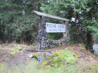
From the parking lot off Rocky Point Road, the Goose heads straight into
Matheson Lake and Roche Cove regional parks. The Goose changes
character again. From the pastoral setting of Metchosin, the trail crosses
into semi-wilderness. The trail surface is still hard packed and comfortable of course, but the scenery gets wilder and greener. Pockets of Western Red Cedar, low lying skunk
cabbage swamp, glimpses of Matheson Lake and Roche Cove, and
creeks emerging from fern forests reward the traveller.
Heading west past Roche Cove, the trail crosses Gillespie Road (use
extreme caution: a blind curve in the road) and skirts Sooke Basin, clinging to the coves and headlands along the north shore to the small peninsula of Milnes Landing.
Savour this section of the Goose. There are few multi-use trails along the west coast that offer cycling this close to the Pacific Ocean. The trail dips steeply down into Veitch Creek
near Hutchison Cove. Most cyclists hustle quickly over the bridge and climb up the other side. But they miss one of the gems of the Goose. Stop on the side of the bridge and
enjoy the spectacular view of Veitch Creek as it flows over exposed bedrock and out into the basin. Sooke River Valley Near Coopers Cove (3 km west of Roche Cove) the Goose heads north across Sooke Road (use extreme caution on this busy highway!) and
visits the neighbourhood of Ayum Creek before heading north into the
Sooke River Valley.
Dwayne's Track and pictures January 28, 2013
View Galloping Goose 4 Rocky Pt Rd to Sooke Rd Jan 28, 2013 in a larger map


We'll meet at last week's stop - the parking lot at 5410 Rocky Point Road. It's about 10 K to the next stop - the intersection of Sooke Road and the Goose. We will board the vehicle left there for the return trip to the Rocky Point Road lot.
We should be able to park Kathy's van here (around 5512 Sooke Road) near the Shell station and mail boxes on the right. This view is looking back along Sooke Road.
View Larger Map
Description from the official guide
From the parking lot off Rocky Point Road, the Goose heads straight into
Matheson Lake and Roche Cove regional parks. The Goose changes
character again. From the pastoral setting of Metchosin, the trail crosses
into semi-wilderness. The trail surface is still hard packed and comfortable of course, but the scenery gets wilder and greener. Pockets of Western Red Cedar, low lying skunk
cabbage swamp, glimpses of Matheson Lake and Roche Cove, and
creeks emerging from fern forests reward the traveller.
Heading west past Roche Cove, the trail crosses Gillespie Road (use
extreme caution: a blind curve in the road) and skirts Sooke Basin, clinging to the coves and headlands along the north shore to the small peninsula of Milnes Landing.
Savour this section of the Goose. There are few multi-use trails along the west coast that offer cycling this close to the Pacific Ocean. The trail dips steeply down into Veitch Creek
near Hutchison Cove. Most cyclists hustle quickly over the bridge and climb up the other side. But they miss one of the gems of the Goose. Stop on the side of the bridge and
enjoy the spectacular view of Veitch Creek as it flows over exposed bedrock and out into the basin. Sooke River Valley Near Coopers Cove (3 km west of Roche Cove) the Goose heads north across Sooke Road (use extreme caution on this busy highway!) and
visits the neighbourhood of Ayum Creek before heading north into the
Sooke River Valley.
Dwayne's Track and pictures January 28, 2013
View Galloping Goose 4 Rocky Pt Rd to Sooke Rd Jan 28, 2013 in a larger map


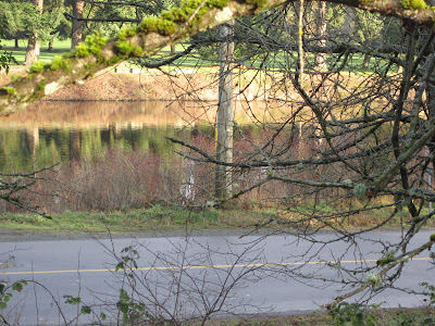
Lots of water and lush vegetation, with all the rain.


Matheson Lake.

Three otters frolicking - only two came close enough to have their photos taken

Steep cliffs - sounds like an invitation to go and look

Remnants of old railway ties.


Sooke Basin.

Did anyone see the Spitfire near 36 km?


Eye test.


Ex Canadian Forces minesweeper.
Below -Telegraph pole from the old days


Sooke Rd and the end of GG4.
Saturday, January 19, 2013
GG3 Luxton to Rocky Pont Road Jan 22, 2013
Directions
We'll meet at last week's stop (parking next the the wild bird seed store at kilometer 18) at 9:15 and hike to the day's destination - the parking lot at 5410 Rocky Point Road. We will board the vehicle left there for the return trip to the Luxton parkade.
View Larger Map
The hike was 12.5K
View Galloping Goose 3 Luxton to Rocky Pt Rd. Jan. 28, 2013 in a larger map
Pictures from the hike.
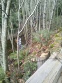


Off we go


Luxton fairground.

New Luxton station

Accelerate down the straightaway.

Rifle Range. It can get pretty noisy here on the weekend.

Lots of ferns along the route.

Must be the right way.

Below - historical monument


First views of the ocean.


Just past the free ranging chickens are two Turkey Vultures. I wonder why there were no chickens in sight. Hmm. Couldn't get a very good picture with the Brownie Hawkeye

Rocky Point Rd and the end. If it seemed long, it was 12.5 km.
Thanks for the pics, Kathy and Dwayne!
Description from the official guide
Just west of Glen Lake and Jacklin Road, the Goose swings south and leaves Langford behind, entering Metchosin, one of the earliest pioneering communities on Vancouver Island. For about seven kilometres, the trail loosely parallels Happy Valley Road, crossing it twice before veering west towards Rocky Point Road at Kangaroo Road.
Where the Goose in the eastern urban sections is used primarily by commuters and neighbourhood strollers, the Metchosin section is a destination of choice. It’s easy to see why. The rural pasture lands, small farms surrounded by hills, lazy creeks, and arbutus-clad outcrops remind users of a day gone-by — when life was simpler and slower and closer to nature.
In 1871, one of the first public schools in Western Canada opened here. The Metchosin School still stands near the corner of Happy Valley and William Head roads, only a short 1½ kilometres from the Goose.
Thursday, January 10, 2013
GG2 Atkins Avenue to Luxton Fairgrounds car park Tuesday, Jan 15, 2013
Hike photos
View The Galloping Goose Day 2 Jan. 15, 2013 in a larger map


The end for this week
Directions
We'll all meet at the centre at 9:15 and car pool with at least two vehicles. We will drop off one vehicle at the trail car park near Luxton Fairgrounds and proceed to the Atkins Road parking to start this section.
There is parking here next the the wild bird seed store, and we know where the Atkins Road parking is - and how to get to it!
View Larger Map
This section is approximately 9K, but we make up for it next week with a slightly longer hike (11K) to Rocky Point Road.
Ad Hoc Hikers who complete any section(s) of the Goose Gallop 2013 will receive a momento indicating the distance walked. If you miss a section on any Tuesday and want to make it up to receive the coveted 55K momento for 2013, please let me know. We're planning to complete the Lochside Trail as well this year - so stay tuned!
Description from the official guide (see links section for the full guide).
Just west of the Atkins Avenue parking lot, the Goose crosses Six Mile
Road. For the next seven kilometres the Goose rides over top of
the Colwood Delta — an immense pile of gravel, up to 100 metres
thick, underlying much of Langford and Colwood. It was built
nearly 13,000 years ago by streams flowing to the sea from glacial ice
west of Langford Lake. You can’t see the delta as such (it’s under foot)
but you can see some of the left over meltwater channels and ponds.
Road crossings interrupt the flow of the Goose all the way to the Luxton
Fairgrounds. The Goose crosses Atkins Avenue (three times), Sooke
Road (three times), Jacklin Road and a few other smaller roads. Sooke
and Jacklin are busy, major roads. Exercise caution when crossing. Use
the cross walks and if you’re cycling, dismount before crossing.
The working landscape of Colwood and Langford is partially shielded by
fern-laden rocky outcrops, pasture land, and low-lying wetlands. It’s a
delightful surprise to enter a shady former railway cutbank on a hot
summer day and imagine the rickety Galloping Goose gas car (circa 1930)
lurching along the old rail line.
Subscribe to:
Comments (Atom)