Monday, November 14, 2011

Christmas Hill and Swan Lake Loop - November 27, 2012

Tack

https://maps.google.ca/maps/ms?msid=209938729472309822028.0004cf810bb4a31043692&msa=0


INSTRUCTIONS
Car poolers meet at the Senior's Centre at 9:15. The drive to the Swan Lake parking lot is about 16 minutes, so anyone wanting to meet at the parking lot should be there by 9:35.
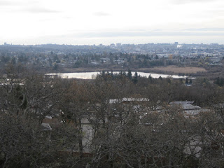
First we will take the trail up to Christmas Hill and do the loop around the top to enjoy the views of Victoria and Saanich. Then we will trek back to Swan Lake and do the lake loop clockwise, crossing the bridge, ending up at the Nature House and parking lot. There is an uphill climb to the top of Christmas Hill, but the loop around Swan lake is almost level. Christmas Hill will take about 1:00 and the lake loop will take about 0:45, for a total of about 1:45 to 2:00. The stone steps on Christmas Hill and the bridge across Swan Lake can be expected to be slippery when wet.  


Three of us did this walk on Tuesday, Jan 3, 2012.  Here is the MotionX track.  There are some alternative routes around the Christmas Hill summit that we can explore on other hikes.


Name:Track 001
Date:Jan 3, 2012 9:33 am
Map:
(valid until Jul 1, 2012)
View on Map
Distance:5.53 kilometers
Elapsed Time:1:06:55
Avg Speed:5.0 km/h
Max Speed:21.1 km/h
Avg Pace:12' 06" per km
Min Altitude:0 m
Max Altitude:102 m
Start Time:2012-01-03T17:33:30Z
Start Location:
Latitude:48.466009º N
Longitude:123.374080º W
End Location:
Latitude:48.465827º N
Longitude:123.374247º W

MotionX-GPS Commonly Asked Questions
  1. What is MotionX-GPS?
    MotionX-GPS is the essential GPS application for outdoor enthusiasts. It puts an easy-to-use, state-of-the-art handheld GPS on your iPhone.
  2. Can I use MotionX-GPS?
    Sure! MotionX-GPS can be downloaded from the iTunes App Store.
  3. How can I display tracks in Google Earth?
    Follow the directions on the Google Earth web site to download and install the Google Earth program. Save the attached "Track 001.kmz" file to your computer. Launch Google Earth, select File, Open, and open the saved "Track 001.kmz" file.
  4. This email was forwarded to me. Where are the attachments?
    Some e-mail programs do not include the original attachments by default when forwarding an e-mail. In this case, the sender must reattach the original files for them to be included.

Please contact MotionX customer support with any comments or questions.
All the best,
The MotionX Team


How to get there:
Getting back on to McKenzie westbound when returning:


Monday, November 7, 2011

October 30, 2012, John Dean Park


INSTRUCTIONS

How to get there
Car poolers will be leaving the centre at 9:15 and should be starting the hike from the parking lot at 10:00. This assumes that the parking lot will be open, as it should be until November.

If Dean Park Road is closed, park on Carmanah Terrace, past the no parking signs. You will see two large water towers and a set of mailboxes. Park beyond the mailboxes. If you are using a GPS to navigate to the park entrance, set it to North Saanich, intersection of Carmanah Terrace and Dean Park Road.
BC Parks Information
BC Parks Map


Information
The first thing you will want to know about John Dean Park is that Dean Park Road, as shown on the Park Map, is closed November to March. This is indicated on the lower right corner of the map. You can park on Carmanah Terrace, beyond the no parking signs. It takes approximately 15-20 minutes to hike 1.2k up the road to the parking lot.
John Dean Park is very well marked. The trail markers are well placed and usually have a "you are here" map. It would be virtually impossible to get lost/disoriented  in John Dean Park. Steep slopes and stairs are clearly identified on the map. There are many man made stone stairs in the trail system. These stairs may be slippery when wet.
Features in the park are the cedar and Douglas Fir forests, the historical locations of the Dean Family, the marshes and the viewpoints. The best viewpoint, by far, is Pickles' Bluff. It is a large outcropping and has a 180 degree panorama. The stairs indicated on the map for the Pickles' Bluff viewpoint are mostly wood and descend down to the viewpoint. These stairs may be slippery in wet weather.
For the hike indicated on the revised map; red indicates the in path and blue indicates the out path. Total hiking time without the side trip from the parking lot to Pickles' Bluff is 70-105 minutes. The side trip to Pickles' Bluff adds 30-45 minutes. Most of the best features of the park are in this hike. John Dean is a great park for hiking; well marked, scenic trails and quite a lot of variety. It is very popular with locals.

Hike Report, October 30, 2012

Track

https://maps.google.ca/maps/ms?msid=209938729472309822028.0004cd648fa35a7fdcef5&msa=0


 This was the less than awesome view from Pickles' Bluff.

 This is what the view was supposed to look like.;-(


 There wasn't much left of Thomson's cabin. Needs renos.


A huge tree fell across the trail. Luckily, it missed us..by a couple of days.
Hike report, Tuesday, Jan 10, 2012


Five of us did this walk today.  Here is the MotionX track for the walk.


Name:Dean Park
Date:Jan 10, 2012 9:51 am
Map:
(valid until Jul 8, 2012)
View on Map
Distance:7.17 kilometers
Elapsed Time:1:24:41
Avg Speed:5.1 km/h
Max Speed:14.3 km/h
Avg Pace:11' 48" per km
Min Altitude:163 m
Max Altitude:299 m
Start Time:2012-01-10T17:51:27Z
Start Location:
Latitude:48.619785º N
Longitude:123.435589º W
End Location:
Latitude:48.619469º N
Longitude:123.435710º W


... and here are some pictures of the great views. 


This is an excellent hike, and we will be visiting this park to do the other trails.