Tuesday, July 19, 2011

Latoria Creek Park - October 29, 2013

Directions
Car poolers should leave the centre at 9:15 to arrive at the trail head by 9:30. We'll be leaving one car at the public washrooms on Ocean Boulevard/Lagoon Road and starting the walk at the park entrance near Latoria Road/Wishart Rd.


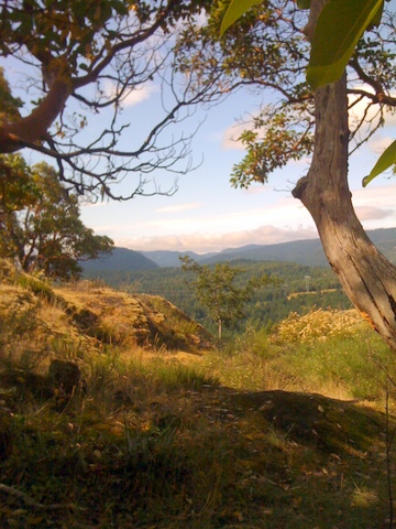
Check the Royal Bay Walk - page 26 of Walk the West Shore.  We will be doing only part of this hike. We will walk through the delightful Latoria Creek Park, cross Metchosin Road and carry on down to Albert Head Lagoon .  There are usually basking seals and other aquatic life on the ocean side of the lagoon and ducks, swans, and herons etc on the land side - not sure what life there will be on the naturalist beach!

Undaunted, we will carry on to walk along the beach to the car we left near the washrooms.


Google map to Latoria Creek Park Trail Head.  Driving time about 15 mins from the centre


View Larger Map

Track


View Latoria Park to Esquimalt Lagoon - October 29, 2013 in a larger map

Slideshow


Pictures


Previous hike report
A slight hiccough on the map front, but our group met up at the trail head opposite the intersection of Latoria and Wishart Roads at around 9:30 as planned.

The walk went as planned, so here are our floral finds for this week including my draft (or daft) attempts at identifying them.  Please help; if you recognize these plants, please drop us an email.


This was a different red berried plant than the red swam berry from last week. My guess - Red Huckleberry (Vaccinium parvifolium).


This was clearly the Oregon Grape, though, with its fruit ripening nicely.


We thought this was probably saxifrage. Not sure.


Common horsetail (Equisetum arvense) - pretty sure. A horsetail at least.


We were pretty sure these two were dogwoods but I'm not so sure now. Is it a marsh violet, perhaps?  Maybe the one above is a marsh violet and the lower one that we thought was the same is a dogwood?


In any event this was Albert Head Lagoon.  We had a break watching a couple of seals and a family of sea otters.  Even the seal pretended to be a sack of concrete or a log until we could verify movement and identify it as a seal!

We walked back via the park, rather than Pelican Drive.  One of our intrepid hikers had a close encounter with a wasp on the community funded foot bridge close to Metchosin Road - a bit too close, in fact, and ended up with four stings.  Sting relief cream is now added to our hiking first-aid kit!- (and another stable door is tardily closed).

This is a great hike of about 60 minutes with some altitude variation, including steps, but with smooth hiking surfaces.  A brief beach sojourn with some nature watching potential is an added attraction.


April 23, 2013, Ross Durrance Trail

Directions 

Google map with directions from centre. It's easiest to click on "view larger map" below to get full map and directions.

This location is about 25 minutes' drive from the centre.  Car poolers should leave the centre at 9:15.  If you want to meet in the trail head car park, please be there at 9:40.

Track for this hike

View Larger Map


3k hike with elevation change of 147 m.  Gentle slope down to McKenzie Bight.  Excellent view of Findlayson Arm and access to rocky beach.  Return on loop with views of waterfalls and streams - a good aerobic workout up steps for some of the way.

I found this review on a page called hiking for fat people. While it is a fair description of the trail, we didn't find it anything like so challenging as this.

Here's a link to  the Walk the West Shore booklet that has information on this and other walks.


Pictures from June 26, 2012 hike (Thanks Dwayne)


Description of August 2, 2011 Hike

Our small group left the centre at 9:15 and arrived at the Gowland Todd car park at around 9:45.  We met another large group of hikers from Sidney at the car park that was on the same mission as we were.  Having exchanged pleasantries, we headed off onto the trail for McKenzie Bight.

We soon realized how much we missed Carolyn when we couldn't really identify the plants on Mckenzie Bight Trail. I'm posting pictures and will try identifying them, but if you get them first, please drop me an email.


This was a large shrub with prolific red berries. I think maybe ribes triste or red swamp currant.


This small plant had small white flowers and grew near the trail. Is this a saxifrage?


There were fantastic views of Finlayson Arm. The tide was out and we managed to see barnacles, mussels, crabs (two types), and a jelly fish.


 We saw this yellow flowering plant near the beach. (Maybe yellow star thistle - invasive?)


We also saw this boat heading to anchor in the cove.


The walk back via cascade trail was very steep, with steps and stairs in various places as well as hand rails in some areas. However, there were always excuses to stop and check out the environment.  For example, this smorgasbord of berries was right next to the trail. Unfortunately, the waterfalls were not in operation on this hike, but we expect them to be working again in the fall after some heavy rain.  Another visit at that time is indicated!


July 3, 2012, Mount Wells Regional Park


Directions for July 3, 2012


How to get there from Victoria:


Follow the Trans-Canada Highway from Victoria, and turn left on Sooke Lake Road. Turn left on Humpback Road. At the intersection with Irwin Road, stay right. Follow Humpback Road to the park
entrance on the right. Allow approximately 30 minutes driving time from Victoria.

Google map with directions from the centre: (Approximately 20 minute driving time from the centre)


The hike to the summit is 1.3 km.

Hike Description from the official guide:


Hike on a steep and challenging trail to the 352-metre summit for sweeping views of Juan de Fuca Strait, Victoria and the Sooke Hills. The trail climbs through Douglas-fir forest and sensitive Garry oak ecosystems to open rocky hilltops dotted with arbutus trees, hairy manzanita and a mosaic of lush mosses. In the spring, native wildflowers such as camas, shooting star and satin flower carpet the slopes. Mount Wells is the only place in Canada where the endangered prairie lupine grows. Please stay on the trail and keep pets on the trail to protect this fragile habitat. Even if wildflowers are not visible, walking off trail can damage bulbs that lie dormant under thin soils. On your journey to the summit, you may see turkey vultures and band-tailed pigeons, or hear the drumming of ruffed grouse. The park is also an important wildlife refuge for animals such as black-tailed deer, red squirrels and alligator lizards.


Car poolers will be at the centre ready to leave at 9:15. If meeting at the car park next to Humpback Reservoir on Humpback Road - please be there at 9:35.


Description of Tuesday July 26, 2011 hike
We arrived at the Mount Wells Regional Park at around 9:35, having set off from the centre at about 9:15 as planned. We travelled via the highway, turning off at West Shore Parkway and turing on to Humpback Road at Ma Miller's Pub.


From the car park we crossed two bridges and Humpback Road following the large diameter concrete water pipe on the way to the ascent.
 The first part of the hike was through forest until we came out above the trees and started to get the excellent views.

We noticed this camas (Cammasia quamash) as we we making our way up from a viewpoint close to the summit.  The $30 guide we bought to identify this plant indicates that while the bulbs of the blue camas are edible, one should avoid eating the meadow death-camas bulb (for obvious reasons). Never having had much of a taste for lily bulbs, I won't find avoiding this one a great problem.

At the summit we saw two survey markers..

and took in the 360 panorama.  The summit was especially satisfying as it was a large flat rock forming an excellent congregating area and viewing platform.
This survey marker was within a few feet of the other one and seemed in much better condition.
We noticed the ghostly-looking Indian Pipe (monotropa uniflora)
and the more robust Oregon Grape (mahonia aquifolium) as we were making the descent.

Although only 1.3 k each way, this seemed a much longer hike, which makes sense considering the approximately 1000 feet we climbed. As Dwayne said - you know you've climbed a fair way when you can look down on planes! We arrived for coffee at Ma Miller's at around 11:50.

Some of us decided to try out the winding and narrow Humpback road on the return trip, meeting up with Sooke Road.

Overall a satisfying shorter hike with good cardio exercise and excellent views.


Tuesday, June 18, 2013 Lone Tree Hill Park

Track, June 18, 2013


View Lone Tree Hill - June 18, 2013 in a larger map


Photo page


View Larger Map

Directions

Meet at the centre at 9:15 and drive to the Lone Tree Hill Park (about 20 mins) to start our approximately 4k ramble.

Report of July 19, 2012 Hike

On the way to the summit we found two excellent view points.


At the summit, we found the BC survey marker


and what we thought was the best candidate for the "lone tree."


Thanks to Carolyn, we noticed the hedgehog dogtail grass


that we managed to photograph and a couple of orchids that we didn't.

Thanks to Phil for inviting us for coffee and the most excellent coffee cake. Phil has a wonderful country home near the park, resplendent with flowers in full bloom and some "bloomin'" bunnies eating the grass. (Very cute - though!)

A great hike with excellent views, cardio exercise, gourmet treats, and good company.